ALERT DAY
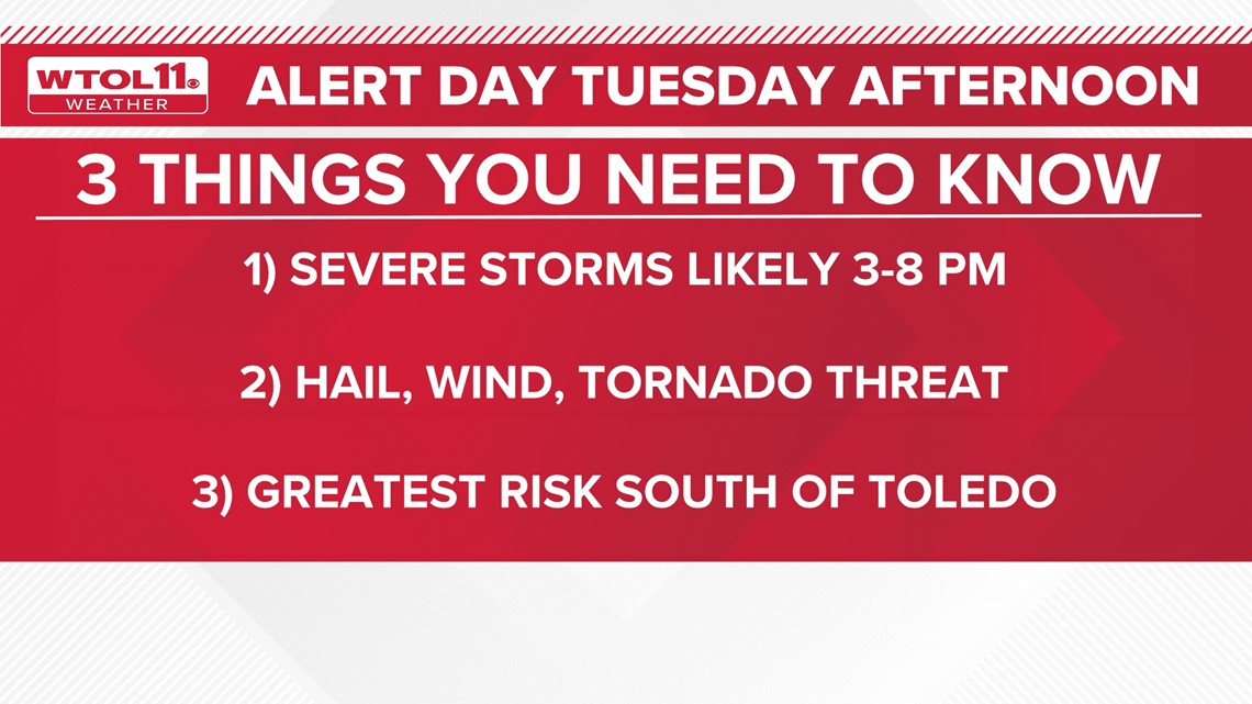
The WTOL 11 Weather Team is forecasting possible severe storms Tuesday afternoon and evening. Here's what you need to know. The WTOL 11 Weather Team has issued an Alert Day for Tuesday afternoon and evening to give advance notice of potential severe weather. The Alert Day is in response to increasing data suggesting that a potential storm system is likely to develop. Severe weather is expected to intensify in central Ohio by mid-afternoon, with large hail and a few tornadoes possible. The greatest risk will occur south of Toledo, with southern Michigan having the lowest risk. The Toledo metro may still see a few strong to severe storms, but the greatest risk lies south of the Maumee River.
Published : one year ago by John Burchfield in Weather
The WTOL 11 Weather Team is forecasting possible severe storms Tuesday afternoon and evening. Here's what you need to know.
Example video title will go here for this video
Example video title will go here for this video
TOLEDO, Ohio — The WTOL 11 Weather Team has issued an Alert Day for Tuesday afternoon and evening to give you advanced notice of incoming severe weather. Stormy spring weather is looking increasingly likely and the latest data has ramped up the severe potential of this storm system.
Here are three things you need to know ahead of Tuesday's Alert Day.
Don't let this dry stretch fool you, though; severe weather will grow increasingly likely in the afternoon. Several hours of dry conditions will enable the atmosphere to destabilize, fueling the thunderstorm threat.
By 3 p.m., discrete thunderstorm cells will fire off as a strengthening area of low pressure moves into central Ohio. Intensifying storms could become severe by mid-afternoon, posing a variety of weather risks.
Hail, wind and a few tornadoes possible
Large hail will be the greatest threat with these discrete supercell thunderstorms and a few hailstones the size of golf balls are possible in north central Ohio. The hail risk will be less substantial in the Toledo metro and southern Michigan.
Additionally, due to the wind shear, or turning in the atmosphere, a few tornadoes may develop Tuesday afternoon and early evening. The tornado risk is most likely across central and north central Ohio closer to the US 30 corridor.
The greatest risk will occur south of Toledo
As a strengthening area of low pressure races into central Ohio, thunderstorms will develop and quickly intensify. The specific storm track will dictate how far north the severe threat reaches. The trajectory of this low pressure system will create the greatest risk of severe weather far south of Toled. Areas like Findlay, Tiffin, Upper Sandusky and Bucyrus should remain extremely weather-aware Tuesday afternoon and check the WTOL 11 weather app for radar and weather alerts.
The Toledo metro may still see a few strong to severe storms, but the greatest risk for hail, wind, and tornadoes will occur south of the Maumee River. Southern Michigan has the lowest risk for severe storms Tuesday afternoon.